 |
 |
In the News II
Thread Rating:
| April 24th, 2026 at 3:43:33 AM permalink | |
| DoubleGold Member since: Jan 26, 2023 Threads: 34 Posts: 4259 | Example of a head scratcher: Using a globe, here's a flight path that crosses the equator twice for a path that doesn't make sense. Why cross the equator? ------------- 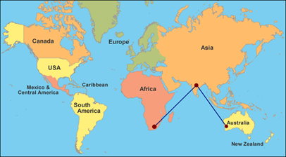 ------------- Using the 1892 map: ------------- 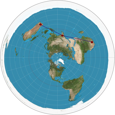 ------------- Gleason's 1892 map with the south pole spread out keeping the water in: 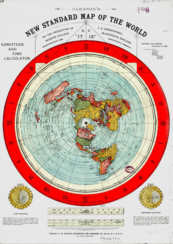 The only answer [according to the maps] is because the south pole is not a point. My second grade teacher showed us a globe with the south pole being a point, so I know this can't be true. Plus, my father had a globe in his office and my father was never wrong because he was the boss. It looks like the trick was differentiating the south pole of the firmament relative to the planet, such that a firmament has a south pole. Like Atlas carrying the firmament (spherical), not the planet (planar). The question becomes how far is the south pole on the other side of Antarctica? |
| April 24th, 2026 at 6:44:10 AM permalink | |
| fleaswatter Member since: Oct 24, 2012 Threads: 5 Posts: 1895 |
In your flight path example I am assuming that the flight is between Perth, Australia and Johannesburg, South Africa. The flight path does not cross the equator twice. 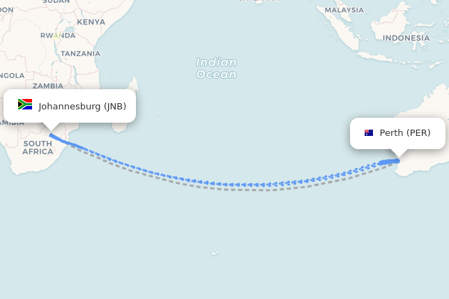 |
| April 24th, 2026 at 7:25:07 AM permalink | |
| DoubleGold Member since: Jan 26, 2023 Threads: 34 Posts: 4259 | I agree your referenced flight path doesn't go through the equator twice. ------------- I checked flights from Johannesburg to Perth using Trip.com [first link I came across]. I didn't notice any flights going through India but there could have been. The cheapest flight was one way for $518 that goes to Qatar, then Perth. The most expensive was $3,168 for an upgraded direct flight. According to the 1892 map projection, Qatar is a little out of the way, which could explain the cheapest price. When using a ball projection, the distance going out of the way to Qatar "looks" like it's much larger [the entire African continent at an angle]. Qatar is north of the equator. In other words, the cheapest price crosses the equator twice. I think this link can be used to determine the difference of the two distances. I've used the Haversine but not the other. ------------ GIS FAQ Q5.1: Great circle distance between 2 points . . . http://www.movable-type.co.uk/scripts/gis-faq-5.1.html ------------- |
| April 24th, 2026 at 12:34:49 PM permalink | |
| DoubleGold Member since: Jan 26, 2023 Threads: 34 Posts: 4259 |
He could have been named after Lamont in "Sanford and Son". I couldn't find his father's name to see if it was Fred but the dates match up. He should have used "All in the Family" as a reference. Funny either way. |
| April 24th, 2026 at 6:19:14 PM permalink | |
| fleaswatter Member since: Oct 24, 2012 Threads: 5 Posts: 1895 | DOJ Adds Firing Squad as Method for Federal Execution
|
| April 25th, 2026 at 3:49:44 AM permalink | |
| DoubleGold Member since: Jan 26, 2023 Threads: 34 Posts: 4259 | Why they're called airplanes [planar devices or linear aircraft models]: Because an airplane [planar] can only be used on a planet [planar], not firmament [spherical]. Implying the part of the planet [planar] containing air within the firmament [spherical]. "over a flat, nonrotating earth" Ask yourself why math needs to be calculated for an airplane over a flat nonrotating earth. It's baffling. This sounds like NASA is removing the projection [the part we see] inside the calcs. Such that they can make it look like something it isn't by changing the map projection of reality, like a magician. Then hand off to the FAA so folks don't crash and get to their destination efficiently without using earth revolving curvature. --------------------- NTRS - NASA Technical Reports Server Derivation and definition of a linear aircraft model August 1, 1988 A linear aircraft model for a rigid aircraft of constant mass flying over a flat, nonrotating earth is derived and defined. The derivation makes no assumptions of reference trajectory or vehicle symmetry. The linear system equations are derived and evaluated along a general trajectory and include both aircraft dynamics and observation variables. . . . https://ntrs.nasa.gov/citations/19890005752 -------------------- Likely FOI docs by NASA: I'd guess there are tens of thousands of these, classified, so folks don't know. ------------------- 15 NASA Research Papers That Admit Flat & Nonrotating! Updated: Jun 23, 2019 . . . https://www.galileolied.com/post/15-nasa-research-papers-admit-flat-nonrotating ------------------- |
| April 25th, 2026 at 5:57:44 PM permalink | |
| missedhervee Member since: Apr 23, 2021 Threads: 170 Posts: 5790 | Looks like somebody wanted to shoot the fat oaf.  |
| April 25th, 2026 at 8:14:48 PM permalink | |
| fleaswatter Member since: Oct 24, 2012 Threads: 5 Posts: 1895 |  |
| April 26th, 2026 at 1:33:11 AM permalink | |
| OnceDear Member since: Nov 21, 2017 Threads: 15 Posts: 1861 | trump not shot again. |
| April 26th, 2026 at 2:39:40 AM permalink | |
| DoubleGold Member since: Jan 26, 2023 Threads: 34 Posts: 4259 | An extreme head scratcher example: Flight from Buenos Aires to Perth [Australia]. With the 1892 map projection, a flight path would be one of the longest because can't go over Antarctica [there's land on the other side]. This free map gets confused with the projection but gets a distance: It looks like the logic wants to go over Antarctica, but it's restricted airspace by a treaty with most governments. ---------- How Far is it Between Perth, Australia and Buenos Aires, Argentina? This map shows the distance from Perth, Australia to Buenos Aires, Argentina. You can also see the distance in miles and km below the map. . . . https://www.freemaptools.com/how-far-is-it-between-perth_-australia-and-buenos-aires_-argentina.htm ----------- If looking on a globe map, should be able to hit the jet stream half-way and fly over Antarctica for a shorter flight. I checked the same flight path website [previously used] and there were no flight paths available. Trip.com has some indirect flights taking over 30 hours [against jet stream?] from price ranges of over $3,000 and up. Compare to the price of $518 [with jet stream?] for the previous indirect Perth flight from Johannesburg through Qatar, so should be about 2-3 times that [not 6 times as much]. Podcast of several men discuss the flight path for a private jet: They're baffled but expect a fake flight to be publicized that it's possible to fly over the south pole. ------------ ...How Will They Fake a Flight Buenos Aires to Perth? Apr 5, 2022 . . . https://www.youtube.com/watch?v=apVeK2MS2UM --------------- A theoretical map of land on the other side of Antarctica: It doesn't have to be ice, such that there could be other ponds. --------------  --------------- Before I show how the system could work, I have to cover a few basics, like the Treaty, etc. And it's a system according to Tesla. |